Oct 19 2008

Bryce Canyon

Published by under Utah,Western U.S.

Bryce Canyon NP is a beautiful park that we did a decent job of visiting in 24 hours.  We got photos at sunset, sunrise, and a really fun 3-mile hike while we were there.  Here are some pictures:

_MG_1650

A broad shot of the Bryce Canyon "amphitheater" at sunrise.  Dave was really happy there were interesting clouds that day.

_MG_1677

Another sunrise shot captures the golden glow

_MG_1705

The tallest formation in this shot is called "Thor’s Hammer"

_MG_1689

This is what I do when Dave’s taking pictures at sunrise

_MG_1765

The hike we did goes right into the amphitheater.  This area is called "Wall Street".  The nearest person to the camera is me (for scale).

_MG_1809

Another viewpoint from our hike.  Fabulous!

_MG_1795

A nice couple from Alaska took this picture of us near the end of our hike

– Meredith

One response so far

Oct 19 2008

View from our Window #6

Published by under Utah,Western U.S.

Here is the view from our tent at the campground at Bryce Canyon NP:

 _MG_1543

We only stayed one night, but it was the nicest setting for our tent so far.

– Meredith

Comments Off on View from our Window #6

Oct 18 2008

Pics from Around Page

Published by under Arizona,Western U.S.

We had a blast at Lake Powell – we’ll definitely come back here!  Here are a few pictures from our time in the area (other than previously posted pics of Slot Canyons and Coyote Buttes):

_MG_1508

Lake Powell and Me

_MG_0868

The full moon over the canyon near our campground

_MG_1373

The Colorado River at an old ferry crossing (Lee’s Ferry) near the Vermillion Cliffs National Monument

_MG_1515

Colorado River’s Horseshoe Bend at sunset

– Meredith

Comments Off on Pics from Around Page

Oct 17 2008

Slot Canyons!

Published by under Arizona,Western U.S.

While we were in Page, we went to Upper and Lower Antelope Canyons, two separate canyons created by the Antelope River (it only runs sometimes; the rest of the time it’s bone dry).  First, I’d like to say that if you ever have an opportunity to go to a slot canyon, take it!  You need to be careful about the weather, because if there is any chance of rain anywhere in the vicinity (I’m talking for miles and miles), it can be very dangerous due to flash flooding potential (REALLY dangerous, like fatality dangerous).  However, as long as the weather cooperates, go to one of these narrow sandstone canyons – you won’t be disappointed.  At the right time of day, the sun hits parts of the walls and creates either a soft glow or beams of light.  The Antelope Canyons are carved out of Navajo sandstone – it’s pinkish red.  So the colors we saw while visiting ranged from a bluish-purple to bright orange.

The Upper canyon is quite a tourist attraction, so unfortunately is quite busy – too busy to get good pictures at times, unless your camera is pointed straight up.  In fact, because of the crowds, there is a time limit imposed on each tour – 1 hour for the standard tour, and 2 hours for a photography tour.  Despite the teeming hordes, it was beautiful.  But Dave and I both preferred the Lower canyon.  Not only was it less crowded, but it was longer, more narrow, and there were different levels that we accessed via stairs or ladders, so it was more fun.  There was also no time limit, so we spent 4 hours in the Lower canyon, versus 2 hours in the Upper canyon.

Here are a couple photos that give you a sense of being in the canyons:

_MG_1245

Here we are inside Lower Antelope Canyon

_MG_1360

One of the ladders inside Lower Antelope Canyon

And here are several photos Dave took of some of light playing on the features in the canyons:

_MG_1253

A window in Lower Antelope Canyon

_MG_1208

Many walls in Lower Antelope Canyon

_MG_1315

Fun lighting in Lower Antelope Canyon

_MG_1351

A small patch of blue sky peeks into Lower Antelope Canyon

_MG_1491

Upper Antelope Canyon’s purple walls

– Meredith

Comments Off on Slot Canyons!

Oct 16 2008

The Wave in Coyote Buttes North

Published by under Arizona,Utah,Western U.S.

In Meredith’s last post, she mentioned how I got lucky and obtained a permit to hike in Coyote Buttes North to go see The Wave. I guess I didn’t realize how lucky I was until I spoke with a few people who had been turned down. There was the guy who walked into the BLM office only 15 minutes after I did. I mentioned my luck to several other people and most expressed some degree of disbelief and usually then offered a story of some acquaintance of theirs who got turned down 5 days in a row. So anyway, I guess the stars were in alignment that day.

As Meredith and I split and she headed toward the Wire Pass slot canyon, I struck out through the northern part of the Coyote Buttes (hence the name). A hike through a sandy hill and a large wash then up and through a notch in a sandstone ridge gave me my first views of the Buttes. These have a mix of white, red and sometimes yellow striations in them that in some cases look like taffy. In the case of The Wave, the surface has been worn almost smooth which really intensifies the effect. I then hiked south along the ridge line for a while, made the climb up a sandy dune slope which is the final approach and there I was in the entrance to The Wave. You can’t see it all until you’re right in it. I wonder what the first person to discover it thought when they happened upon it. It’s unlike anything I’ve seen in nature. For a photographer, it’s somewhat of a bonanza. It’s hard to know where to point your camera first.

I spent about 4 hours there after arriving then retraced my steps back to the trail head. The hike from end to end is about an hour and a half including time to take a bunch of pictures along the way. That makes about 7 straight hours in the direct sun. I had lots of water to last all day but I was pretty worn out at the end. I slept well that night! Here are a few pictures I took that day:

_MG_1027

Above: In the entrance to the Wave, looking back over Coyote Buttes

_MG_0948

Above: Looking down the “heart” of the Wave

_MG_0947

Above: Inside the Wave

_MG_0951

Above: Two other people in the Wave to give a sense of scale

_MG_1020

Above: Near the top of the Wave where the lower part of a butte begins the Wave

_MG_1068

Above: There are lots of abstract patterns on some of the walls in the Wave

_MG_1097

Above: Looking up the “secret passage” of the Wave, a narrow path to the side of the main part

_MG_1122

Above: Looking back down the “secret passage”

_MG_1144

Above: on the hike back, a typical view of the Coyote Buttes

_MG_1166

Above: much of the hike to the Wave was across slickrock like this.

_MG_1149

Above: Another view of the Coyote Buttes

– Dave

Comments Off on The Wave in Coyote Buttes North

Oct 16 2008

Solo Hike!

Published by under Utah,Western U.S.

There’s a place on the Utah/Arizona border called Coyote Buttes that is a natural wonder and a very productive spot for photographers.  The site is protected and managed by the Bureau of Land Management.  They allow just 20 visitors per day.  Half the visitors reserve their spot months in advance online, and the other half participate in a daily lottery (each morning’s lottery is for a permit to enter the next day).

Dave was very interested in going to this place, so we stopped at the BLM office near the site to ask about the lottery, how to participate, etc.  We got there at 3 pm on the day we arrived in the area.  Dave asked, "I know this is a long shot, but…"  After the park employees chuckled a bit, one said, "Actually, this is your lucky day!  A man who won a permit in this morning’s lottery left early and never claimed his ticket.  So you can buy his permit for tomorrow!"

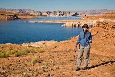
This was incredible luck.  But the permit was for just one person to enter, so we decided Dave would go to the Coyote Buttes, and I would go on a hike that departs from the same trailhead but is not in the permit area.

I’ve never been on a solo hike before, but the BLM people assured me that it’s ok to do this hike solo, and that there would be other people on the trail as well because it’s a pretty popular hike to do if you don’t get a permit into the Coyote Buttes.  The trail is 3.5 miles round-trip, and goes through a slot canyon called Wire Pass to Buckskin Gulch, a very long canyon that people do backpacking/camping trips through.  My plan was to hike to the intersection with Buckskin Gulch, see how I felt, and then either turn back, or hike into Buckskin Gulch for a bit to check that out before turning back.

I was a tiny bit nervous about the solo hike, so Dave an I got two-way radios at the Walmart in Page, AZ.  Never mind the fact that I was in a canyon most of the time and there was no way the radio would work in there.  It was more of a peace of mind thing.  🙂

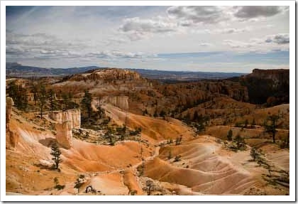
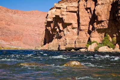
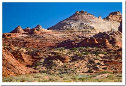
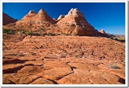
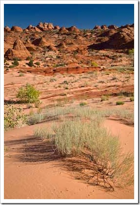
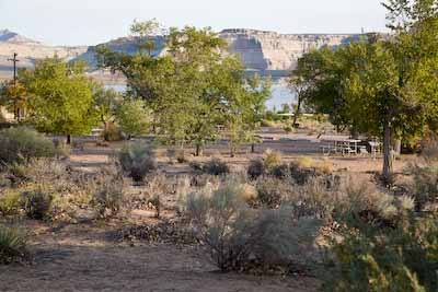
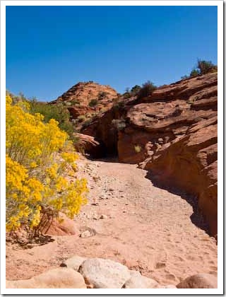
So Dave and I arrived at the trailhead the next morning, hiked together for about a quarter mile, and then he went off toward the Buttes and I continued down a beautiful wash toward the canyon.  Here is a picture I took from the wash:

IMG_1004 

Just one of many outstanding views while hiking in the wash of the river

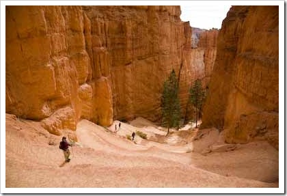
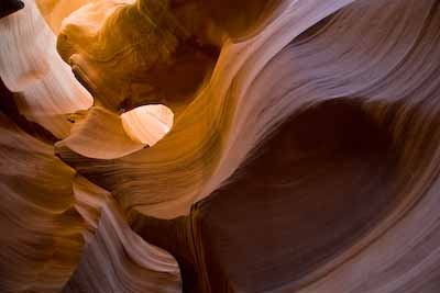
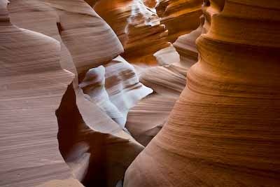
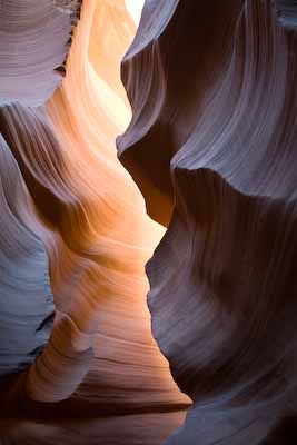
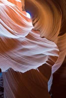
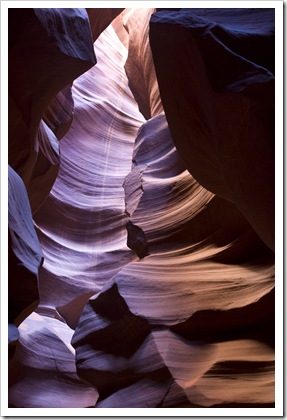
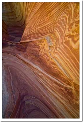
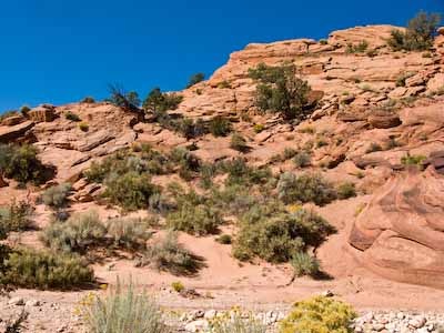
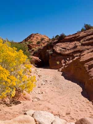
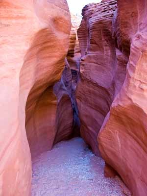
After about a mile, I reached the first narrows.  It was my first time in a slot canyon, and it was one of the coolest things I’ve seen on a hike (more on other slot canyons in the area in a separate post!).  The canyon was about 3 – 4 feet wide in most parts.  Here are representative pictures:

IMG_1009

The wash leads into the first narrows section

IMG_1037

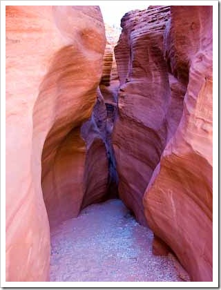
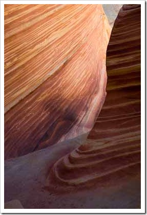
The beautiful sandstone walls of Wire Pass range from about 20 feet to 100 feet high

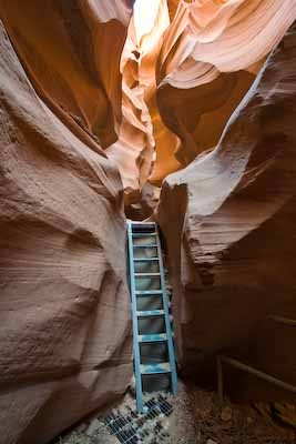
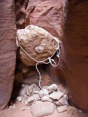
Pretty soon after I reached the canyon, I hit my first obstacle.  The people at the BLM office told me there was one part of the canyon where a boulder was stuck between the walls, creating a place where a hiker has to lower him/herself down to the next section of the canyon.  They said the boulder was chest high.  With all due respect, it’s probably only chest high on a pro basketball player.  It was just over my head.  Not that I knew this when I got there, because I was on the high end looking down.  It looked pretty scary, and I sat on the rock for a full five minutes before I worked up my courage to go down.  In my head, I thought, "I’m sure I can get down ok, if ungracefully, but can I get back up by myself?"

I decided to go for it, partly because I wanted to push myself, and partly because I knew it would be a pretty long, boring day for me if I gave up this early and went back to the car when Dave wouldn’t be back from taking photos for at least 5 hours.  Here is the picture I took of the boulder from the bottom:

IMG_1018

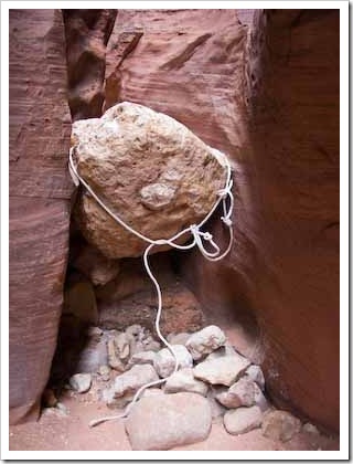
This giant boulder was taller than me!

I wish I had put something in the picture for scale, but you’ll have to trust me that it’s a big boulder.  The rope you see is supposed to help people climb up the boulder, but it was useless because the boulder is round; if you put your foot in the toeloop, it just goes forward underneath the boulder.

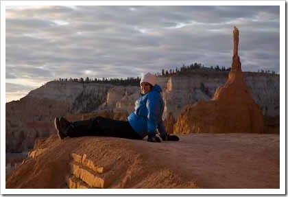
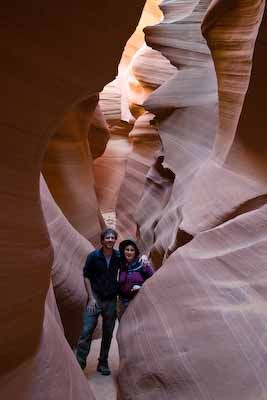
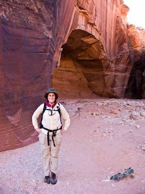
The rest of the way to Buckskin Gulch was beautiful, fun, and I went along without incident.  The other drops along the way were easy to step down, or manage by sitting on the rock and dropping down from there.  I didn’t see anyone else the whole time I went through Wire Pass on the way toward Buckskin Gulch.  When I got to the intersection, I met three guys who were eating lunch (they were hiking Buckskin Gulch on a multi-day trek).  One of them took my picture:
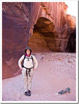
IMG_1030

Proud solo hiker

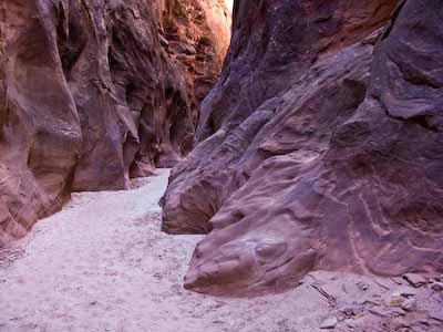
You can probably tell by the picture that I was pretty satisfied with myself at this point, doing this solo hike, conquering boulders, etc.  I decided to turn left into Buckskin Gulch (upstream, if there were any water at that point, but it was bone dry).  I hiked about a half mile into the canyon, then turned around.  Buckskin Gulch was wider than Wire Pass, but I still wouldn’t want to get caught in there when there was any water.  Here is a picture I took there:
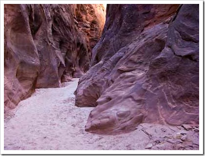
IMG_1033

Buckskin Gulch

I went back to the intersection, ate lunch (peanut butter and jelly!), and headed back through Wire Pass.  I started to see people on the way back (must have been that time of day).  When I got back to the giant boulder, a couple was just finishing helping each other up there.  I wanted to see if I could do it myself, but I must have hemmed and hawed a little too long, because the guy in the couple asked me if I wanted help, and I accepted after unsuccessfully trying alone for about 30 seconds.  I probably could have done it eventually, but I’m glad I had help – it took a lot of energy.  After I was out of the canyon, I reached for my two-way radio to try to call Dave.  But it wasn’t in the holster!  ARGH!

I assumed that it must have fallen off when I was climbing up that damn boulder.  Luckily, that wasn’t too far away, so I went back to it to look.  There was a guy about to come up the boulder when I got there, and I asked, "Do you see a two-way radio down there?"  The man said, "Ah HA!  No, it’s not down here, but we saw it further down the trail."  Because they didn’t know whether someone lost it coming or going, they had placed it on a ledge where they found it.  Then man said it was about 300 yards away.  Doesn’t sound too bad, except now I would have to do this stupid rock all over again.  Ugh.  I was starting to get tired.

I dropped down the boulder (much easier the second time), ran down the trail as fast as I could, seeing several groups of people who all assured me that the radio was on a ledge, not far now, etc.  I ditched my pack and hiking poles at a more open spot and started running.  I found my radio on a ledge of the canyon.  It was almost at the intersection of Buckskin Gulch.  I must not have put it on my holster tightly enough after lunch.

I raced through the canyon one more time so that I’d catch up with the last people I saw, because now I knew I would need help getting up that boulder (it wasn’t easier the second time).  I stuck near my new friends and made it up that rock one last time, this time with my radio secured inside my pack.  Once I got out into the wash, I had a mile left to hike to return to the car.  With the running back and forth, I probably hiked a little more than 5 miles that day.  I was exhausted, but I couldn’t have been happier.  What a fun day!

Dave got some amazing pictures on his adventure that day – he’ll post them separately.

– Meredith

One response so far

Oct 15 2008

View from our Window #5

Published by under Arizona,Western U.S.

We’re camping again!  This is the view from our tent at the campground at Lake Powell in Arizona near the Utah border:

_MG_1540

It’s beautiful here – there is so much to do!  We were only going to stay for three nights, but we extended to four nights because this place is like a playground.

– Meredith

Comments Off on View from our Window #5

Oct 14 2008

We’re Sorry, Tent!

Published by under Arizona,Western U.S.

We have recovered from the bad attitude we adopted while in Monument Valley, and have decided that we shouldn’t have taken our frustration out on our tent.  In fact, we *need* that tent for the rest of the trip, so, we hope the tent accepts our apologies.

– Dave and Meredith

PS – we couldn’t find a new four-season tent on our way to the Grand Canyon.  We even went out of the way to Flagstaff and every outdoor gear store in town.  No luck.

Comments Off on We’re Sorry, Tent!

Oct 14 2008

Pics from the Grand Canyon

Published by under Arizona,Western U.S.

Here are a few pics from our time at the Grand Canyon:

_MG_0724

Sunset at Desert View

_MG_0829

Sunrise at Mather Point

_MG_0861

Dave and Meredith at Mather Point (It’s COLD at Sunrise!)

That wraps it up for the Grand Canyon.  I’m feeling much better and we are off to Lake Powell.  Our itinerary page has been updated as well – we have a plan now.  🙂

– Meredith

Comments Off on Pics from the Grand Canyon

Oct 13 2008

Dave’s Grand Canyon Mule Ride

Published by under Arizona,Western U.S.

While Meredith languished in the motel room (writhing in agony from what I’m told), I headed over to the corral behind the Bright Angel Lodge to meet up for my mule ride. There are two types of mule rides into the Grand Canyon that one can sign up for. One is an overnighter where you ride mules all the way to the bottom of the canyon, stay overnight at Phantom Ranch, then ride the mules back up. That’s very expensive – more than we thought it was worth – so instead we signed up for the other type of mule ride which is a one-day roundtrip to a place named Plateau Point.

I showed up at the corral at 8am. A few minutes later, the mule wranglers brought the mules into the corral. The group heading to Plateau Point and the group going to Phantom Ranch all met up at the same time so there were about 50 mules for us:

_MG_0667

While the wranglers did some final prep, we were given the usual pre-trip briefing by one of the head guys who takes care of the mules:

_MG_0668

Here’s a close-up from that picture (nice and blurry). Notice the awesome mustache with handlebars:

_MG_0668-2

Whenever I’ve spoken to people who have done a mule ride at the Grand Canyon, they always mention how narrow the trail is and how the mules walk right on the edge. They consistently make it sound like it’s really risky and how they thought they would go over the edge at any moment. I was ready for a real adrenaline rush but I was disappointed actually. The trail is not narrow, I didn’t feel like we were hugging the wall at all, and while the mules do walk on the outer edge of the trail, it turns out that they’re trained to do so (I can’t remember why – it may have been something to do with how they interact with hikers that they pass). These things are also really strong. They’re bigger than most horses and the ride was very smooth. I’ve picked one of my pictures that shows the trail at its narrowest. Not so bad:

_MG_0684

About a mile down the trail, we passed desert bighorn sheep about 5 feet off the trail. Apparently they’re used to humans now so they just sat and watched us ride by. This one lay on the rock above the trail and peered over:

_MG_0678

About noon, we reached Plateau Point and took 20 minutes for lunch. It was a nice overlook down on the Colorado River. Here’s yours truly after we saddled up to ride back to the top:

_MG_0699

My mule’s name was Junky. I asked our guide Kevin why he was named that but he didn’t know because it was named before he started guiding. Junky was a little stubborn in that he didn’t want to go as fast as the lead mule but otherwise he was great. I guess Junky was just a joke name.  Anyway, supposedly a mule is a cross between a male donkey and a female horse but I think a rabbit is involved in there somewhere. This should be apparent when you look at Junky’s ears:

_MG_0700

Here’s a shot of Kevin tending to one of the mules after we got to the top and in the corral:

_MG_0716

Kevin then handed all of us our certificates. Apparently, I am “now a member of the Order of the Master Mule Skinners of the Grand Canyon Trails with rights and privileges to boast of this accomplished feat forevermore.” Get ready folks. You’re about to get an earful of boasting for a looooooong time:

 _MG_0866

In the end, I’m glad I did the mule ride but I don’t think I’d do it again. I think for most people, half of the thrill is the ride on a big animal but I’m pretty comfortable riding a horse/mule/whatever. The other half is the scenery which was definitely great but the trail is not a loop: the return trip is going up the same trail you came down. By the time I was halfway back, I was bored and just wanted it to be over.

When I got back to the motel room, Meredith was a bit stir-crazy and ready for company. I ran out and got a pizza to bring back to the room. We sat on the bed eating it and watching the Pats game but I passed out somewhere in the middle of the third quarter. Apparently mule riding is more tiring than you might think.

– Dave

2 responses so far

« Newer Entries - Older Entries »